China Weather Network News Today (19th), the snowfall in Northeast China has reached its peak, and the newly added snow will be unfavorable to traffic. In addition, due to the influence of cold air, it is expected that from tomorrow (20th), a large range of rain and snow will be on the line again, and the temperature will fluctuate obviously. Before the arrival of cold air, there will be a "cliff-jumping" decline.
A new round of large-scale rain and snow is on the road in the middle and east of Northeast China during the peak period of snowfall
Affected by the eastward movement of the high-altitude trough, since last night, there have been obvious snowfall weather processes in eastern Inner Mongolia and most parts of Northeast China. It is expected that the snowfall will continue. Today, the daytime will be the strongest period of precipitation. There are heavy snow and local snowstorms (10 ~ 16 mm) in parts of central and eastern Jilin and northeastern Liaoning. During this snowfall, the depth of newly added snow in southern Heilongjiang, central and eastern Jilin, northern Liaoning and other parts can reach more than 5 cm, and the local area is more than 10 cm. The Central Meteorological Observatory issued a blizzard forecast at 06: 00 on February 19.
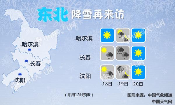
The snowfall will not take too long, and it is expected to come to an end on the night of the 19th, but it will have a great impact. On the 19th, the heavy snowfall in central and eastern Jilin and northeastern Liaoning may bring inconvenience to traffic. For example, some sections of Heda Expressway passing through northeastern Liaoning and eastern Jilin will encounter heavy snow. In addition, highways such as Suiman and Hunwu may also be adversely affected by snowfall and new snow.

At the same time, due to the influence of cold air, it is expected that there will be heavy snow and local snowstorm in parts of Ili Valley, Tianshan area and Tacheng area in Xinjiang from 08: 00 on the 19th to 08: 00 on the 20th. Moreover, snowfall is accompanied by strong winds and cooling, so we should also pay attention to prevent the adverse effects of snowfall, snow and wind-blown snow that may occur in some areas.
In addition, from next Monday, with the southward movement of cold air and the strengthening of southerly warm and humid airflow, cold and warm air will jointly create a large-scale rain and snow process in the central and eastern regions from 20 to 22, and the southernmost boundary between rain and snow can reach Huanghuai and Jianghan. It is estimated that there will be small to medium snow or sleet in the eastern part of northwest China, north China, south-central part of northeast China, Huanghuai and western Jianghan, and heavy snow or blizzard in some areas from 19 to 23; There are small to moderate rains in Jianghuai, eastern Jianghan, Jiangnan, southern China and the eastern part of southwest China, and heavy rains in some areas.
The temperature in many places has risen like warm spring, and the temperature is now "jumping off a cliff" next week.
This weekend, the central and eastern regions of China ushered in a warm-up climax, and the temperature in many places set a new local record. For example, in Guangzhou, as of 16: 00 yesterday, the highest temperature reached 29.2℃, setting a new record in mid-February.

Today, the temperature in North China, the eastern part of Northwest China and the south of the Yangtze River will generally reach high points, and the range of the highest temperature above 20℃ will be extended to Henan and Shandong, and the eastern part of Northwest China will also exceed 20℃, and the south of the Yangtze River will reach about 25℃. It is estimated that among the provincial-level cities, Beijing, Xining, Jinan, Nanchang and other places are expected to break through the new high temperature this year and generally reach the local "Yangchun March" temperature level.

This weekend, the temperature in most parts of the country rose as warm as spring. The picture shows the beautiful advection fog sunrise in Qinzhou by aerial photography. (Photo: Li Binxi)
However, the warming situation will be completely broken by cold air next week. Due to the high temperature rise in the previous period, the temperature will fall "off the cliff". It is estimated that from 08: 00 on the 19th to 08: 00 on the 21st, the average temperature or minimum temperature will drop by 4 ~ 6℃ in the northern part of the south of the Yangtze River, the middle and lower reaches of the Yangtze River and most areas in the north of China. Among them, the temperature drop in most parts of northern Xinjiang, western Gansu, Ningxia, central Inner Mongolia, southern Northeast China, central and western North China, most parts of Huanghuai and Jianghan will reach 8 ~ 10℃, and the local temperature will exceed 4 ~ 6℃. Most of the Bohai Sea and the Yellow Sea will have northerly winds of 7-8 grades and gusts of 9 grades. The Central Meteorological Observatory issued a gale cooling forecast at 06: 00 on February 19th.

At the time when winter and spring seasons alternate, the cold air is still very active, and the weather is often warm and cold, reminding everyone to pay attention to cold and warmth to avoid catching a cold.
